Extreme weather modelling with satellite imagery
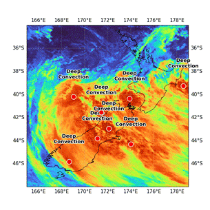
This research project applies deep learning and remote sensing to detect, forecast and analyse extreme weather events such as cyclones and floods using real-time satellite imagery. By integrating advanced spatiotemporal models, the research aims to enhance early warning systems, enabling more accurate and timely predictions that support disaster preparedness and response.
Methodologically, the research leverages time-distributed Convolutional Neural Networks (CNNs) combined with Long Short-Term Memory (LSTM) networks to capture and model spatiotemporal dependencies in weather data streams. This approach has been demonstrated as effective in advancing satellite imagery-based weather forecasting.
Reference: Utilising a time distributed CNN-LSTM to address spatiotemporal dependencies in weather forecasting using satellite imagery (10.1007/978-981-96-7033-8_1)